

|
|
|
|
 |

|
 |
BMW Garage | BMW Meets | Register | Today's Posts | Search |
 |

|
BMW 3-Series (E90 E92) Forum
>
Central Pennsylvania: Crossing Mountains, Covered Bridges, and Cornfields by BMW
|
 |
| 09-09-2015, 04:06 PM | #1 |
|
Lieutenant Colonel
 948
Rep 1,910
Posts |
Central Pennsylvania: Crossing Mountains, Covered Bridges, and Cornfields by BMW
 Featured on BIMMERPOST.com  But that particular adventure came in the middle of my recent trip across central Pennsylvania. I was primarily searching for entertaining ways to cross some of the mountain ranges in this part of the state, along with any interesting historical sites that cropped up. I started outside of Harrisburg, where the Susquehanna River was shrouded in mist.  A Railroad Too Big For Its Bridges I later learned that the overgrown stone pilings seen in this photo and the preceding one are all thats left of the Pennsylvania Railroads first two bridges across the Susquehanna. The original wooden bridge operated from 1849 to 1877, but its single track became a severe bottleneck for the PRRs line to Chicago. The piers were expanded, and an iron, two-track bridge was built in 1877. After only 20 years, however, it, too, proved inadequate to meet the railroads growing traffic.  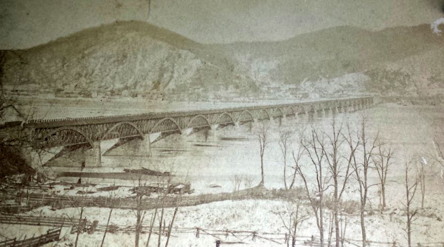 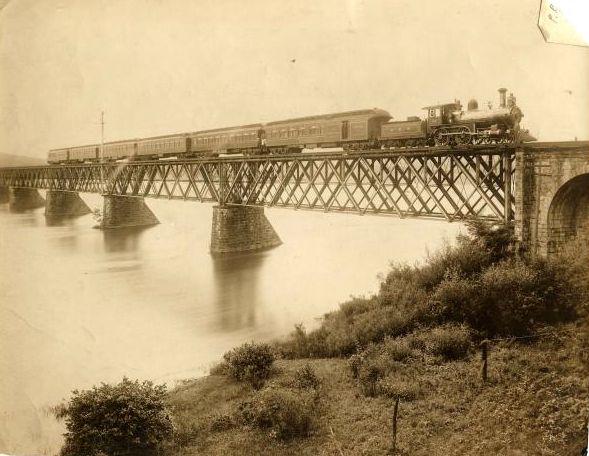 The need for a more permanent, four-track crossing led to the creation of the magnificent Rockville Bridge in 1902. Its 48 stone arches stretch for about 3,800 feet across the river, making it the longest such bridge in the world. It is still in use for freight and passenger service to this day, although it was downsized to two tracks in 1997. High winds had occasionally blown modern containers right off the railroad cars and into the river. With only the two center sets of tracks, spilled containers were expected to land on the bridge. In 2010, however, another one managed to make it into the Susquehanna.   Apparently this problem doesnt apply to Amtraks passenger train cars. Or so we hope Duncannon, PA A beautiful drive up the west bank of the Susquehanna brought me to Duncannon, at the confluence of the Juniata and Susquehanna Rivers. This is the towns new (1902) Pennsylvania Railroad station.  Nearby, a muddy, mosquito-infested walk ended at the old six-arch stone railroad bridge across Sherman Creek. It pales in comparison to the Rockville Bridge, but hey, history is history. Stone bridges seem to last forever, and this one is also still in use. Long before this bridge was built, all the land west of the Susquehanna and north of Blue Mountain was the legal property of Native Americans. Nonetheless, many colonial squatters built cabins and farms in this area. Among them was Simon Girty, Sr., who brought his family here in 1749 and settled on the banks of Sherman Creek. Well hear more of this family, and especially Simon Girty, Jr., in due course.   The train tracks now hug the banks of the Susquehanna. As indicated in the old photo, below, the tracks used to run right through the center of town. The buildings in the modern photo are the same ones, although significantly modified over time. (Historical Duncannon photos courtesy of Duncannon Sesquicentennial.)   This quaint brick building is missing some of its more extravagant original features, but its managed to serve as the Duncannon National Bank (1889-1926), the Perry County Telephone & Telegraph Company (1926-1936), the United Telephone Company of Pennsylvania (1936-1963), and the Duncannon Presbyterian Church Annex (1963-present).   Marie Katherine Steward was born in Duncannon and would have been 7 years old when the national bank opened. She was a direct descendant of Patrick Henry but went on to fame as Marie Doro, an actress on stage and in silent films during 1903-1924. By all accounts she was an excellent actress, but only a few of her films still exist (the rest having deteriorated beyond repair). She is buried in the Duncannon Cemetery.  I had hoped to hike up to the top of Hawk Rock and get a photo from its spectacular vantage point, looking down on Duncannon and the Susquehanna. Unfortunately, it was completely enshrouded in the low-lying fog, ruling out any pictures. Its a popular spot along the Appalachian Trail. The trail, in fact, descends into Duncannon at almost exactly the midpoint of its 2,180-mile length. The Doyle Hotel is a very popular rest stop for hikers. Given its proximity to two major rivers, Duncannon has flooded on many occasionsso be sure to time your Appalachian hike accordingly! 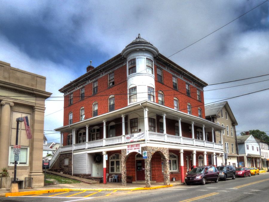   My favorite spot in Duncannon was this view along Little Juniata Creek. In the distance is the 1890 High Street Bridge, which (with its curved upper and lower chords) is the only pony lenticular bridge in Pennsylvania. The Appalachian Trail runs directly across this bridge as it leads into Duncannon. 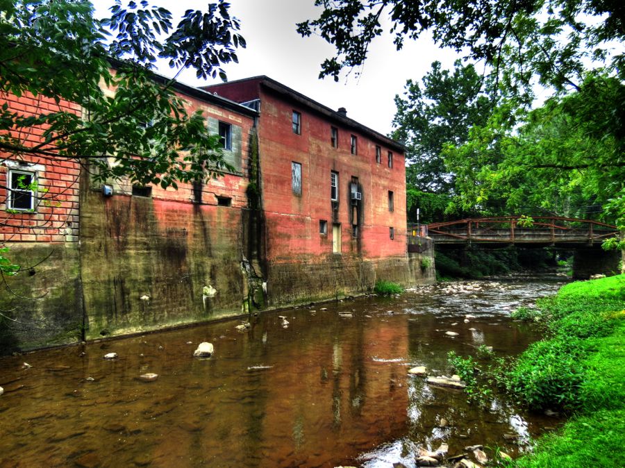 This house used to be the manse for the Presbyterian Church. The steep terrain hasnt changed, but the streets are wider now, and the picket fences have disappeared.   Looking down the hill, I spotted this 1940 Ford sedan, complete with modern sunshade in the windshield. As the generation of drivers and hot rodders who loved these old cars passes on, there is diminishing interest in thembut there are still a lot of really nice ones around.  Clarks Ferry transported freight and passengers across the Susquehanna from 1788 to 1838, when the first of many bridges was built. (One after another, these bridges were swept away by floods or knocked down by ice flows. The current one has been in place since 1986, but my long-term bet is on the river.) This was the Clarks Ferry Tavern, which was built in about 1790 and is currently undergoing restoration. Archeological digs have turned up any number of pottery shards, nails, pipes, etc.along with a gold hatpin, adorned by a diamond. Due to the many floods, farm cultivation, and years of construction, it is not uncommon to find toy soldiers from the 1950s right next to Indian arrowheads from 1500 BC.  My final stop in Duncannon was to find the 1804 log church. Its a 1970 recreation of the towns first church, situated on the original site. Nearby, I couldnt help noticing the unusual tombstone of Frances V. Shull, who passed away when only 27. Her husband John Kirkpatrick was a railroad trackman and remarried soon after her deathbut little seems to be known about Frances herself.   Why Did the BMW Cross the Mountain? From Duncannon, I took the twisty and scenic Highway 849 to Newport, PA. Newport would be an interesting place to explore, but I only had time to see the old railroad station. In 1903, the Pennsylvania Railroad relocated its tracks here after closing and filling in the Pennsylvania Canal. The station was added in 1905, but its best days were long ago. 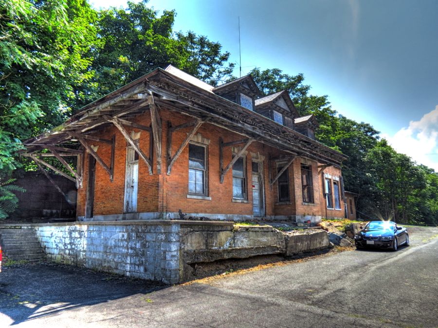  Pennsylvania has been an industrial powerhouse since the late 1700s. The Juniata Furnace settlement started operations in about 1808, and several of its historical sites survive as part of Little Buffalo State Park. The Blue Ball Tavern was built sometime between 1790 and 1810, with conversion to the current frame structure in about 1865. The tavern now serves as a museum and library for the state park.  Shoaffs Mill began grinding grain in the mid-1830s and continued in business for 100 years; the mill is still operational today. It wasnt open on the day of my visit, but a peek through the window showed some of its equipment.   The mills massive metal wheel is 31 feet in diameter and supported by the spindliest spokes imaginable. It replaced the original wooden wheel in 1916.  Leaving the state park, the driving fun began in earnest on Pennsylvania Route 74 (Veterans Way) as it climbed and crossed over Spruce Hill. It was the first of a number of mountain crossings on this trip, and, while not terribly long, its switchback corners were a good source of entertainment. In contrast to so many of the cars Ive owned, the 335i was able to ascend at any rate that I chose, practically leaping uphill from one corner to the next. And thats in stock tune: with more turbo boost, Im sure I could have left an impressive trail of driveshafts, transmission parts, and other expensive detritus behind me!   On the other side of Spruce Hill, I located the Academia Covered Bridge, which is the longestand newestsurviving covered bridge in Pennsylvania. It was built in 1902 to replace an earlier bridge and stretches 278 feet across Tuscarora Creek. It uses a pair of curved Burr Arch trusses, which are more difficult to build but far stronger than most other designs. The bridge was in active use until 1962; the highway department was going to demolish it, but the Juniata County Historical Society came to the rescue, taking ownership and renovating the bridge 1962 and again in 2008. (Historical note: Inventor and builder Theodore Burr died mysteriously in 1822 while overseeing construction of another covered bridge about 50 miles from here. Despite being the most prolific bridge builder of his time, he was penniless at his death. The location of his unmarked grave is not known.) 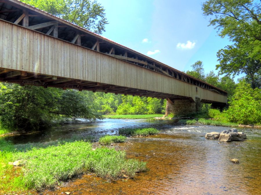  Incidentally, if youve ever wondered what it takes to renovate a covered bridge, check out the photos at the Juniata County Historical Society. Its a much bigger undertaking than I had realized. The Academia Covered Bridge was so-named because of its closeness to the Tuscarora Academy. The school opened in 1839, becoming the first institution of higher learning in the area. It initially focused on Latin and Greek classics but later added practical courses in Book Keeping, English, and modern, ancient, and American history. This is the only building from the Academy that has survived: It started life as a church in 1816 and was used by the Academy as a classroom (downstairs) and dormitory (upstairs) starting in 1853. According to the 1854 school catalog, For Board, Tuition, Washing and Room Rent, per annum$110. Fuel and light are charged extra. After the Academy closed in 1911, the building served as a public high school for a short time. It is now the Tuscorora Academy Museum.  On my way to the Academy, I passed by this stately farmhouse and outbuildings, which were owned by the Patterson family in the mid-1800s. Im not sure what the little buildings to the left might have been, although the one with two doors looks suspiciously like a necessity (i.e., outhouse).  Just for my friend Jody, who is a great admirer of bank barnsi.e., those built into the side of a hill for easy access to upper and lower levelsheres a picture of the Patterson barn, which is one of the handsomest examples Ive seen in a long time. 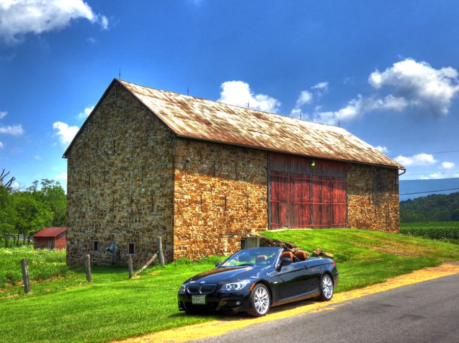 In a field behind the farm, a much older stone building looked for all the world like a fortified house from the days of the French and Indian Wars. It was built by a man named Beale, but otherwise little is known about the place. In the mid-1700s, this part of Pennsylvania, on the eastern slopes of the Allegheny Mountains, was the frontier, and clashes between Native Americans and European settlers were all too common. In particular, following General Braddocks massive defeat at Fort Duquesne in 1755, members of the Iroquois Confederacy of Indian Nations flooded into central Pennsylvania, creating much mayhem and driving many of the settlers away. Unless they caught the settlers, of course, which is another story entirely. In fairness, most of the settlers had moved onto Indian lands, in defiance of the existing treaties.  A (Port) Royal Racetrack Back when mills were powered by water, it was fairly common to build a millpond to ensure a steady supply. Compare these two photos of the Old Port Dam, outside of Port Royal, PA. The dam was destroyed by a flood in 1936 and never rebuilt. The creek remains, however, as does the 3-story house on the far side. The large building in the historical photo (courtesy of the Port Royal 200th Anniversary website) was an ice house, for storing ice harvested during the winter for later use throughout the year.   The Pennsylvania Railroad station at Port Royal was dismantled 46 years ago, but the nearby Hotel Royal is still there (minus its grand porch). It was built in 1902 and served railroad passengers until about 1947, featuring comfortable rooms, a good dining room, and a small movie theatre. These days, the sign in the front door seems rather unnecessary. 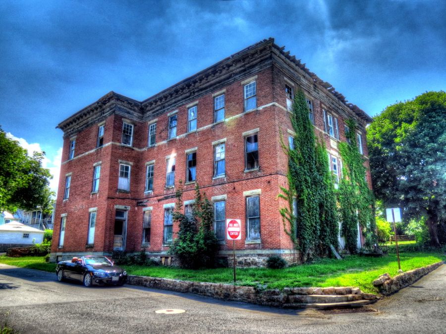 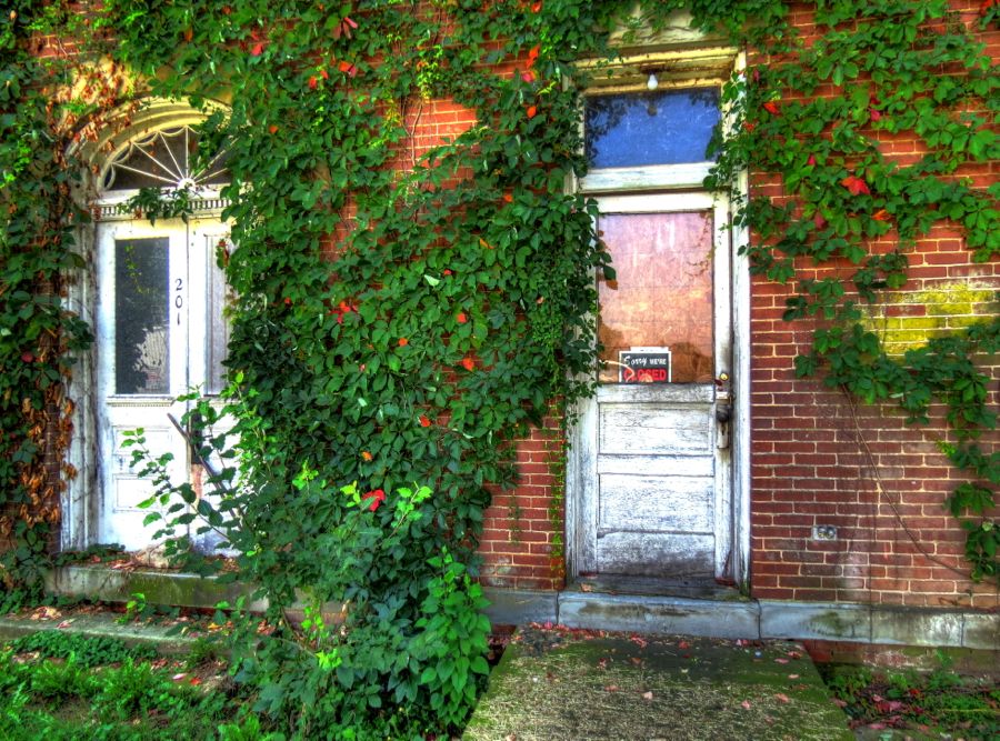  In this old photo, the Hotel Royal is visible in the background, behind the railroad crossing guards. Thats right, this function was once performed by people! (Automation strikes again.)  My primary goal in visiting Port Royal was (naturally) to find the half-mile Port Royal Speedway. This was an easy challenge, since it is situated smack in the middle of the town, with houses on two sides and an elementary school on another! The racetracks grounds were open, but access to the track itself wasnt possible.   Like many dirt oval speedways, this one grew out of horse racing at the fairgrounds. Car racing began in 1938 and has continued ever since, interrupted only during the World War II years. Some vintage racing action is available at Port Royal Footage and Port Royal Speedway Classics. (Photos below courtesy of Port Royal 200th Anniversary and OneDirt.com. Modern sprint car racing remains one of the most visceral and dangerous forms of car racing; regarding the second photo, both drivers emerged okay.)   The Pennsylvania Railroad Station in Mifflin is no longer used, although the tracks are still active for Norfolk Southern. The original station, which included a large hotel, no longer exists (sigh ) (Historical photo courtesy of Pennsylvania Railroad Stations: Past & Present.) 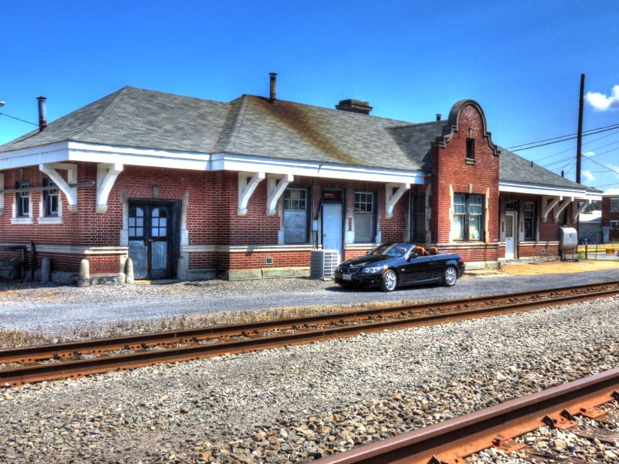  Who Is There To Mourn for Logan? As my first day was drawing to a close, I was anxious to find Logans Spring before sundown. Getting there involved going through Lewistown, where I enjoyed Monument Square. The statue honors the Logan Guards, one of the first Union militias sent to guard Washington, DC after the outbreak of the Civil War. The 1843 Mifflin County Courthouse in the background now houses the countys historical society and Chamber of Commerce. 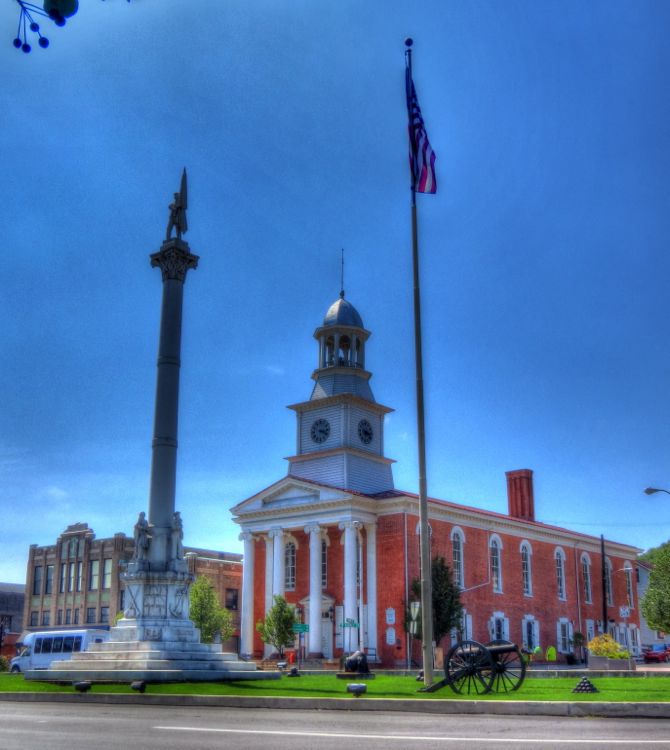  Road construction in Lewistown further hampered my search for Logans Spring, and a cluttered and confusing temporary interchange led me on an unintended 20-mile detour off course. (When in doubt, navigate by the sun and stars!) Eventually, however, I found Tea Creek, and I knew I was close.  Considered by many historians to be the noblest of American Indians, Tal·ga·yee·ta was born in about 1725 along the West Branch of the Susquehanna River. His father, Cayuga Chief Shikellamy, was a close friend of Pennsylvanias Colonial Secretary, James Logan. When Tal·ga·yee·ta was born, his father had him baptized by Moravian missionaries and given the English name Logan, after his great friend. As a young man, Logan moved to the vicinity of what is now Reedsville and built a small cabin near a spring next to Tea Creek. Here, Logan welcomed all visitors, Indians and white settlers alike. (Painting courtesy of ExplorePennsylvania.com and Robert Griffing.)  Logan counseled peace between the Iroquois Confederacy and the colonial settlers, and he refused to participate in the French and Indian Wars or Pontiacs Rebellion. There are many stories of his kindness and friendship to all in this area, including the following (abbreviated version) from William Brown, who later became one of Mifflin Countys first judges:
The spring mentioned in Judge Browns story is located about 4 miles away; this one is the spring by which Logan lived during 1766-1771, before he moved to the Ohio country. Its modern iron cap has been overgrown by moss and vines, but the property owners keep the site of Logans Spring carefully mown.  The rest of Chief Logans story will have to wait for a future visit to the Ohio River. For now, I will just quote his eloquent message to Lord Dunmore (the colonial governor of Virginia), as dictated to Simon Kenton, Simon Girty, and John Gibson on October 26, 1774. Logans Lament was published in newspapers across the colonies and subsequently quoted in Thomas Jeffersons Notes on the State of Virginia:
With thoughts of Chief Logans tragic life running haphazardly through my mind, I found a nearby motel for the night and had dinner at Smittys Sports Bar & Grill in Milroy. I had to smile when I noticed a large poster of a sprint car on the wall behind the bar: Eric Parker, a frequent competitor at the Port Royal Speedway and the winner of the 2014 Pennsylvania Sprint Series Championship, is sponsored by Smittys. And I have to say that it was the best burger Ive had in a long time!   The Appalachian Ridges and Valleys The next morning, I retraced my tire tracks to Lewistown (minus the 20 miles of off-course excursion). There I found this historic 1813 skateboard ramp, just waiting for a stoked dude to come along and grab some major air.  Okay, it wasnt really a skateboard rampat least originally. Its called the Old Stone Arch Bridge over Jacks Creek, and it was part of the Harrisburg to Pittsburgh Turnpike.  Elsewhere, the Lewistown Junction railroad station is still in use, although the streetcars have gone. Its the oldest surviving structure from the Pennsylvania Railroad, having been built in 1849. These days, service is down to a single Amtrak passenger train per day in each direction.   Leaving Lewistown, my path wandered more-or-less along the Juniata River on Pennsylvania Route 333 to McVeytown. Just before Jacks Mountain Road, I encountered this intriguing old log house. The inside looked solid enough but a little too mad creepy for exploration. (Maybe I watched The Blair Witch Project once too often.)   Jacks Mountain Road provides ample driving fun as it twists and turns steeply while gaining 1,700 feet of elevation. In 1743, frontiersman Jack Armstrong stole a horse from a Delaware Indian named Mushemeelin, who in turn tracked Mr. Armstrong down at the Juniata River Narrows and promptly hacked him to pieces. Horse thieving was a common practice among both frontiersmen and Indians, but it invariably led to retaliation, escalation, and sometimes all-out warsand, in this instance, to the naming of a mountain. (Historical note: The full story of Jack Armstrongs death is convoluted. Death on the Juniata: Delawares, Iroquois, and Pennsylvanians in a Colonial Whodunit, by Professor David C. Hsiung, provides a historians detailed description and analysis, including the role played by Chief Logans father, Shikellamy, in the investigation and punishment of Mushemeelin.) Meanwhile, back to Jacks Mountain. It is in the midst of the Ridges and Valleys section of the Appalachian Mountains and offers terrific views of Ferguson Valley to the south  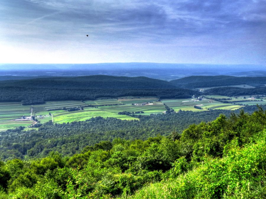 and Kishacoquillas Valley and Stone Mountain to the north. The majority of the farms in Kishacoquillas Valley are owned by Amish families. Clues to such ownership are not obvious from the distance of nearly 2 miles, but they can be discerned. 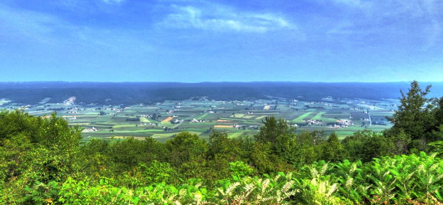   Speaking of which, as much fun as these Pennsylvania roads are, you have to be especially alert for slow-moving buggies and wagons.  Id been by the Greenwood Furnace State Park before, back in 2009 (see In Search of the Lost and Forgotten), but I had to stop briefly for another look at its handsome dam and spillway.  The Names of Roads (or Why Did the BMW Cross the Cornfield?) As most of you know, Im always curious about road names and what led to them. McAlevys Fort Road was a case in point: had there been a fort somewhere nearby? Was anything left of it? Before embarking on my trip, I learned that William McAlevy had been born in Ireland in 1728 and came to Colonial America in about 1746. Although what is now Huntingdon County, PA was solidly Indian Territory, McAlevy nonetheless settled here in 1765 with his wife and children. As related by McAlevys great-great-great-granddaughter, The first necessity that faced them on completing their journey was protection from neighbors who antedated them as residentsvery unneighborly neighbors, the Indiansand this necessity was met by building a fort. With a lot of online research, I ascertained that his large log blockhouse had been either on top of a specific hill near the current hamlet of McAlevys Fort or at least very close by. I was determined to get to the top of the hill and investigate. A little scouting around led me to the Laurel Run Farm, where I asked a young woman if it would be all right if I drove to the hilltop. She said it would be finebut then looked rather skeptically at my low-slung 335i (with the MSport suspension, which barely cleared her gravel driveway). I thanked her and soon found myself on a tractor path headed toward the hill.  As I continued to climb steeply uphill, the path eventually disappeared and I was in the midst of a cornfield! (All in a days work for historical tourists.)  I stopped for another photo a little further on, admiring the sweeping view from the hill and thinking how its 360-degree visibility would have made a perfect spot for a fort. Back in the car, I realized that my lack of forward momentum was a problem. I could have made it all the way to the top (probably) with a running start, but now my summer Bridgestones were just scrabbling ineffectively. I decided it was a good time to park and walk the final hundred yards.  The view from the hilltop was even better. See the little black dot in the middle of the first photo below? Yep, thats the faithful BMW, once again abandoned while I wandered around. 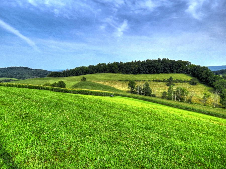  On top of the hill I found the small, beautifully tended McAlevys Fort Hilltop Cemetery. And after checking the tombstones at some length, I discovered the grave of General William McAlevy. 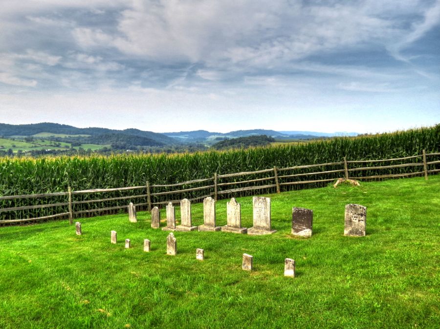  McAlevy was an ardent supporter of the American Revolution and organized a militia in its support. His unit fought sporadically against the British, local Tories, and their Indian allies. At the end of the War of Independence, McAlevy was promoted to a brigadier general. Under the original Articles of Confederation, the new United States encountered many economic and other problems. James Madison, Alexander Hamilton, and other Federalists called for a strong central government, while Patrick Henry and other Anti-Federalists championed States rights and opposed such a move. Eventually, the 1787 Constitutional Convention, meeting in secret, developed a proposed Constitution. Although the new government blueprint was very controversial, after fierce debate it was narrowly adopted in all 13 of the original Statesbut only after the Anti-Federalists insistence on an accompanying Bill of Rights. Gen. McAlevy was not an ardent supporter of the new Constitution. In fact, he led an armed insurrection in Huntingdon, threatening government officials, damaging property, and interrupting court proceedings. Along with similar uprisingsespecially in Rhode Island, which nearly resulted in civil war in that statethe fate of the Constitution was in jeopardy. Over time, however, support for the Constitution far outweighed McAlevys and others opposition. The general remained active in Anti-Federalist politics until his death in 1822 at age 94. So thats the story behind McAlevys Fort Road. While wandering back down the hill, I was relieved to see that the patient 335i was right where Id left it. I guess most cars built within sight of the Alps have incredibly strong parking brakes!  Dubsites Versus Esherites Continuing northwest on this same road, I stopped briefly at Whipple Dam State Park. The dam and lake were originally built to power Osgood M. Whipples sawmill starting in the 1860s. By 1897, either the pine and hemlock forests were decimated or Mr. Whipple just tired of the business; regardless, the sawmill shut down, and the lake was used for recreational purposes.  Returning to McAlevys Fort Road, I stopped at Doanes Bones Barbecue for some excellent pulled pork. While waiting for my carry-out order, I couldnt help chuckling at this display of signs in the dining room:  A little further along, I went looking for whatever might be left of the Monroe Iron Furnace. I knew roughly where it had been, but my first view of the area wasnt encouraging. Or was it?  Sure enough A little ways into the woods revealed a 30 x 30 x 20 foot furnace, overgrown by vines but in fairly good condition. The iron works operated from 1846 to 1864, with a foundry for producing cast iron stoves added late in the process. Why the Monroe works went out of business, when so many others did not, is not known. As for the furnace today, I would guess that not one passer-by in a hundred is aware of its existence. 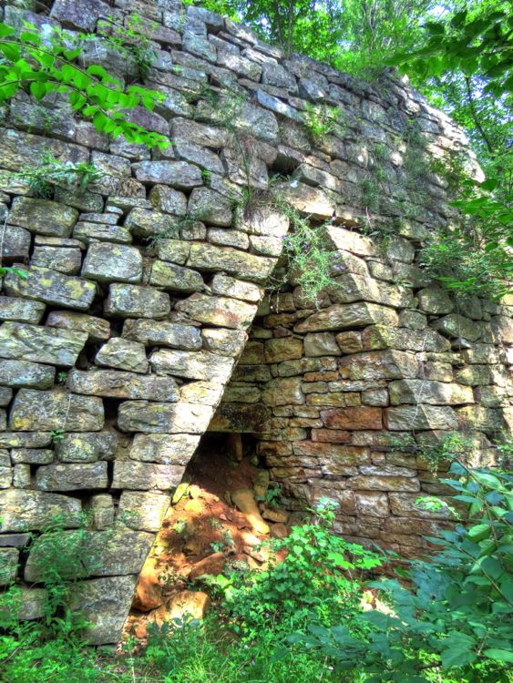 McAlevys Fort Road eventually ended at the small town of Pine Grove Mills, a few miles from State College. Among other historic sites, the town featured the 1858 St. Albans Anglican Church and, next door, the 1834 Pine Grove Presbyterian Church. According to the latters website, the church building is virtually unchangedother than the addition of indoor plumbing and electricity.  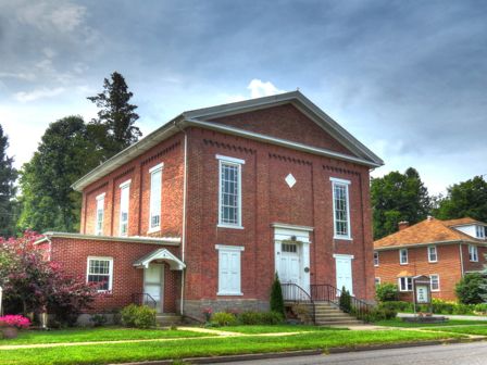 I bypassed both State College and Boalsburg, having been there before (see Sometimes They Come Back To Life; both places are well worth a visit). In the Linden Hall historic district, I found the Rock Hill School, which is a frame, one-room schoolhouse, built in 1893. Prior to its closure in 1937, eight grades were taught here. It subsequently served as a community center and recently underwent a comprehensive renovation.  The Dubsite Evangelical Church stands across the street from the school. It was formed in 1897 as a result of the split between the Dubsites and Esherites within the original Evangelical Association. The followers of Bishop J.J. Esher were more traditional, insisting, for example, on holding services in German. Bishop Rudolf Dubs and his followers were more progressive, allowing English-language services and instituting Sunday school programs. The two factions reunited in 1922, which may have led to the disuse of this church. Despite needing renovation, its Gothic Revival appearance is quite handsome. 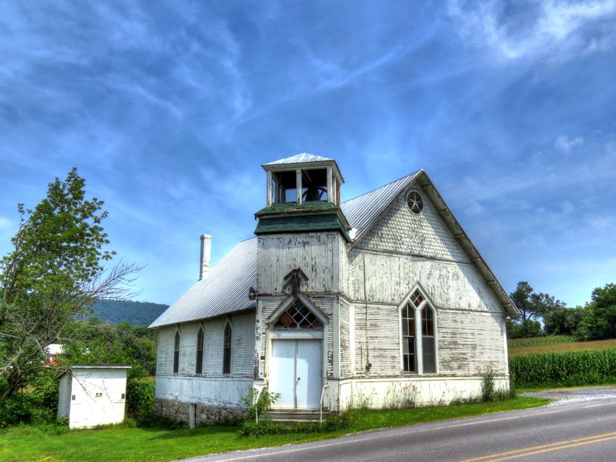 As strange as it was to encounter evidence of the warring Dubsites and Esherites, the Neff Round Barn was more unusual yet. This beautiful structure was designed by schoolteacher Calvin Neff when he retired to become a farmer in 1910. The interior was arranged to simplify the movement of hay between the fields and the livestock. Hay and farm vehicles are still stored within, although the cows have apparently taken up residence elsewhere.  A mile or two past the Neff Barn, I turned onto Old Fort Road and began to wonder about the origin of its name (I swear, its a miracle that I ever manage to complete one of these trips!) Colonel James Potter built a fort here in 1777 for defense against the Indians allied with the British at the start of the Revolution. Nowadays, theres nothing left at the site other than a brand new Sheetz store. Bible Road led me to Egg Hill Road, which snaked its way up the mountain in proper West Virginia fashion: that is, narrow, bumpy, and nary a guardrail to be seen.  At the top, the old Egg Hill Church still stands proudly, even though minus its steeple and sorely in need of paint. Remember the Evangelical Association? It began holding religious classes on this hilltop in 1810 and soon progressed to miraculous camp meetings. The church was built in 1860, using pine boards of varying widths and a stone foundation. (And by the way, Jody, this is a bank church, much like your beloved bank barns!) The Egg Hill Church apparently sided with the Esherites in the late 1800s, but it was abandoned in 1927 not long after the reconciliation between the factions. That a wooden church has survived so long in an abandoned state is testament to its good German construction. (Historical photo courtesy of Penn State University.)   By the way, if you Google Egg Hill Church, you will find numerous lurid stories about its minister going mad in the late 1800s, poisoning the entire congregation, beheading the Sunday School children in the basement, and then hanging himself from the bell tower. Such an event would have been widely reported in the newspapers of the time, but there are no such articles. (No ghosts were harmed in the telling of this story.) The Names of Roads, Part II Penns Creek Road offered a pleasant and scenic jaunt eastward, and, when I reached the hamlet of Coburn, I decided to detour off my planned route and continue following the creek for a while longer. When I noticed that I was now on Tunnel Road, I began to wonder how Well, you know the rest. Eventually the road reached a dead end, where I found this unusually sturdy pedestrian bridge. It looked as though it might have once been a railroad viaduct, and it offered a nice view of Penns Creek. This creek, incidentally, arises from a spring in Penns Cave, about 14 miles upstream. Penns Cave is one of the few caverns open to the public where you tour by boat.   Safely back on land, I encountered an Amish family who were sightseeing nearby. They ranged from grandparents to parents to at least 5 children, and all were traditionally dressed in dark coats and straw hats or plain dresses and bonnets, respectively. The girls scurried away at the sight of der English, especially one toting a camera, but I had a nice chat with the older boys and later their mom. I asked the oldest son where they had been touring, and he mentioned the tunnel and the numerous hummingbirds there. As to its location, he pointed vaguely back in the direction of where I had just been. I retraced my steps, sighted a line from the bridge into the woods, and, sure enough  Yet another road had lived up to its name! Later research indicated that this was the Beaver Dam Tunnel on the Lewisburg & Tyrone Railroad, which later merged with the Pennsylvania Railroad. It was drilled and blasted through the hill in 1877 and was never lined with bricks or other reinforcements. There is a twin tunnel a few miles away in Poe Paddy State Park; the rail line and both tunnels were abandoned in 1970. 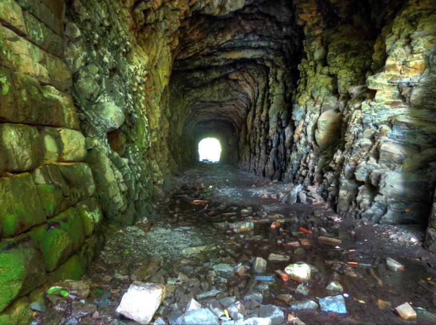 As I was photographing the tunnel entrance, I began hearing voices behind me saying Ouch! As the voices got closer, I thought perhaps the Amish boys had come back to see if Id found the tunnel. Imagine my surprise when I turned around and saw three college-age kids wearing swim trunks and carrying large innertubes, gingerly walking toward the tunnel with bare feet! Amish they were not.  A few minutes later, I drove back toward Coburn and stopped for another photo of Penns Creek. There in the distance were my new acquaintances, enjoying a languid afternoon on the water. (The college boys, that is, not the Amish family )  Did I mention that many horse and motorcycle riders have traveled through the Beaver Dam Tunnel without mishap, whereas horses refuse to go through the similar Poe Paddy Tunnel? And motorcycles typically quit running partway through? The tunnel entrances at Poe Paddy are now bricked closepurportedly because the ceiling is collapsing. A Disappearing Road, Guarded by Butterflies Back on Penns Creek Road, I passed by farm after farm, with each one a study in rustic beauty.   Woodward, PA seems to be gradually moving in the ghost town direction. Its old stores may be closed, but they were still plenty scenic. (Just outside of town, in contrast, Camp Woodward has a very successful history of helping train kids in action sports, gymnastics, and cheerleading.) 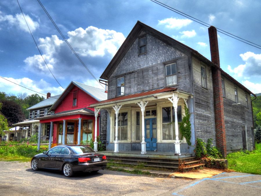 I hustled the 335i around Paddy Mountain and then up, over, and down Penns Creek Mountain, Middle Ridge, Booney Mountain, and Hetrick Ridge on Highway 235, enjoying every moment. The majority of the roads in central Pennsylvania seemed to be in pretty good shape, and few had unexpected patches of gravel or similar hazards. 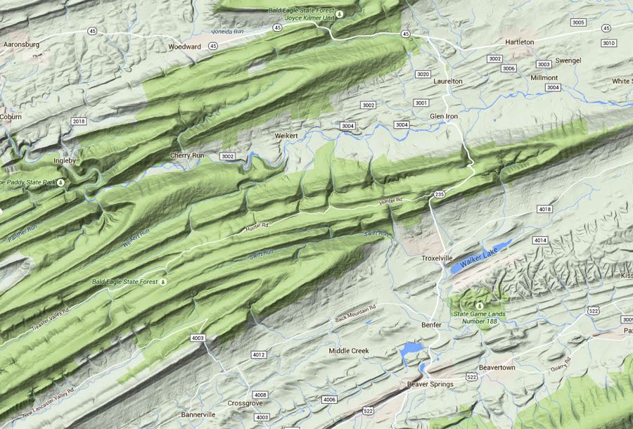 I found the handsome Manbeck Mennonite Church on Stage Road (which has its own story, no doubt). This building started out as the St. Luke Evangelical Church in 1888, but by 1955 there were only two parishioners left. It is now thriving as a more-elaborate-than-usual Mennonite house of worship.  Eventually, I ended up on Shale Pit Road outside of Beaver Springs. Instead of ending at the expected shale pit, however, the road just disappeared into a body of water.  I realized that, at one time, the road had continued right across Middle Creek on the bridge seen in the middle of this photo. That was before a dam was built downstream, creating Faylor Lake and flooding the road. The ducks didnt seem to mind.   Along the old roadway, I was attacked by a crowd of newly minted orange sulphur butterflies. They apparently took umbrage when I moved in for an ultra-close view and promptly swarmed about haphazardly for several seconds before returning to their beloved mud hole.  Covered Bridges and the Brief Tale of Autumn and Dalton At one time, Pennsylvania had approximately 1,500 covered bridges. It still has more than any other state, although the number has dwindled to fewer than 200. I encountered several such bridges on this trip, in addition to the one already noted. Clockwise from upper left, we have the 1890 Wahnetas of Clays Bridge over Little Buffalo Creek; the 1855 Millmont Red Bridge over Penns Creek; the 1871 Gross Bridge, originally over Middle Creek but moved to one of the Beaver Springs when the creek was dammed; and the 1886 Red Covered Bridge over Wild Cat Creek.     Covered bridges were known as kissing bridges back in the day, when young couples could stop their buggy mid-bridge for a bit of snogging out of sight. Such bridges are still romantic, and its common to see various declarations of undying love spray-painted onto the interior walls and beams. In this instance, young Autumn has expressed her love for Dalton Michael in touching and affectionate termsand then returned at a later date to carefully cross out each of the loves and all the little hearts. Nuts, another endearing teenage summer romance, gone with the wind 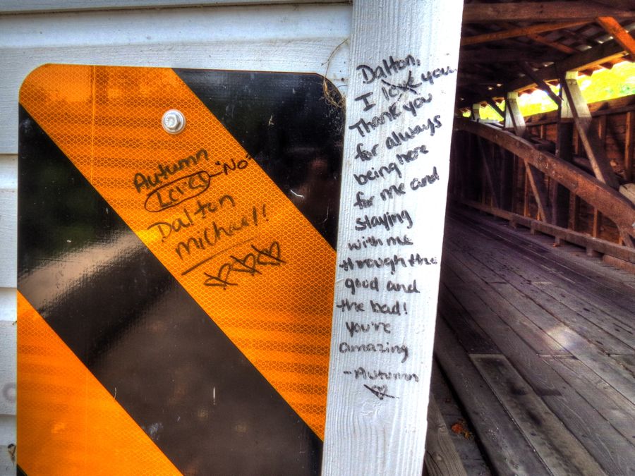 Most of the surviving covered bridges in Pennsylvania and elsewhere have been restored at least once, using federal or state funds, and are in fairly good condition. The Dimmsville Covered Bridge over Cocolamus Creek is a sad exception. From the side view, it looked a bit uneven and saggy.  The easy-to-reach end of the Dimmsville bridge was on private property, but a brief search through the underbrush revealed the old road that used to lead to the other end. As I approached, its precarious condition was downright startling. Unless its owner acts quickly, Im afraid the Dimmsville bridge will collapse under the next heavy snowfall.  Liverpool and the Legend of Simon Girty With my trip nearing its end, I reached the Susquehanna River town of Liverpool. It was settled in 1808 by the Stailey family and named for their home in Liverpool, England. The town thrived as the midpoint of the Pennsylvania Canals Main Line, which ran from Duncannon through New Buffalo, Girtys Notch, and Selinsgrove to Northumberland. The canal was sandwiched between Front Street in Liverpool and the Susquehanna River. (Except where noted, historical Liverpool photos are courtesy of A Pictorial History of Liverpool.)  The Owens House provided tavern and hotel services to travelers for roughly 150 years. People traveling on the canal could just stop right in front of the building (as seen in the photo above). The Liverpool railroad station, however, was on the other side of the Susquehanna River, and reaching the hotel required a half-mile ferry ride. As suggested by the ungainly covered stairs, Owens House is now an apartment building.    The development of railroads soon put the Pennsylvania Canal out of business. It was drained in the early 1900s and later filled in, at which point someone went and built Pennsylvania Route 15 right overtop of it. This is the modern view from Front Street, with the river beyond the busy 4-lane highway.  Elizabeth Reifsnyder was born in Liverpool in 1858 and graduated from the Womens Medical College in Philadelphia at age 23. Two years later, Dr. Reifsnyder sailed to Shanghai, China and started one of the first hospitals in the country, serving as both the administrator and chief surgeon. One of her first patients was a woman with a mammoth ovarian cyst, which was so large that the patient looked virtually shapeless. Dr. Reifsnyder successfully removed the cyst, which was found to contain 22 gallons of fluid! After this success, patients flocked to the new hospital for treatment. The good doctor served in China for 31 years, returning to Liverpool in 1914 and living out her remaining years in this house on Front Street. (Chinese etching of Dr. Reifsnyder performing the ovariotomy courtesy of Harvard Medical School.)     I believe this log building was the Shuler Brothers gun factory in the mid-1800s. Brothers Samuel, John, and Joseph produced high-quality rifles and pistols that are prized by collectors. Pictured below is one of their pivoting over and under double rifles, with silver inlays and outstanding brass work.    I had one more stop to make before heading back homeone of historical interest both generally and personally. In 1986, as I was towing my Sports Renault race car up Route 15 to the Watkins Glen racetrack for the first time, I saw a very large, prominent rock outcropping between the road and the Susquehanna River. I immediately recognized its distinctive shape as a place that Id seen at age 11, when my family was on an extended camping trip from Maryland to Canada and back. I stopped briefly at the adjacent picnic area and enjoyed rediscovering this scenic spot. Over the next 10 years, I saw it again several more times on subsequent trips to the Glen. Until my recent trip to central Pennsylvania, however, I was completely unaware of the name or history of the place. I learned that its called Girtys Notch, after the notorious Simon Girty. Girty was born in Lancaster, PA in 1741 and grew up near Harrisburg. His father was killed in a bar fight with an Indian when Simon was 9. Subsequently, he, his stepfather, mother, and two of his brothers were all captured by Indians from the Iroquois Confederacy during the French and Indian Wars in 1756. As 15-year-old Simon looked on, his stepfather was scalped and burned alive at the stake. Simon, his mother, and his brothers were all taken prisoner by the Indians. Simon was adopted by the Senecas, and his brothers were similarly adopted by the Delaware and Shawnee Indians, respectively. Although released several years later, Simon preferred the Indian life and worked as a guide and translator in the Ohio Territory. Before long, he became reviled in American history for having sided with the Indians against the colonists before, during, and after the American Revolution. Often called the White Savage, he is known to have led a number of Indian attacks against settlers and to have been present at the horrific torture and killing of Colonel William Crawford. Historians differ as to whether Girty laughed at the Colonels misfortune or tried to persuade his captors to spare Crawfords life. To his credit, Girty is known to have acted with Chief Logan to save the life of their frontiersman friend Simon Kenton after he was captured by Shawnee Indians in Ohio. 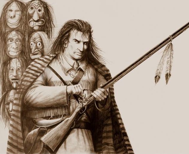 Following General Mad Anthony Waynes defeat of the Western Indian Confederacy at the Battle of Fallen Timbers in 1794, Simon Girty escaped to Canada. Local legend in Pennsylvania holds that he followed a circuitous route that led him to the riverside mountain at Girtys Notch, hiding out here for several days, and leaving a cache of gold hidden in a cave before continuing north to Canada. At Girtys Notch, the Half Falls Mountain reaches directly down to the Susquehanna River. The first road here was built precariously around the hillside, immediately next to the river. Later, in building Route 15 in the 1920s, a passageway was blasted through the mountain, leaving the rock outcropping that I was familiar with. The highway crew was careful to avoid damaging an existing stone profile, which locals claimed resembled Simon Girty.   Having learned this history, I was anxious to revisit Girtys Notch. As I approached the spot, however, I began to realize that Route 15 had been widened to 4 lanes since my racing days. In the process, they had blasted away even more of the outcropping and closed off the entrance to the picnic area.  I found a place to park safely, and I considered the possibility of crossing the highway, scrambling over the tall dividing wall between the north and south lanes, and reaching what was left of the outcropping. Given the heavy flow of rush-hour traffic from Harrisburg, common sense prevailed, and I had to settle for this photo of Girtys Notch, taken from behind a guardrail. Ill get there the next timeespecially since Im told that the rock profile of Simon Girty still exists!  Thats all well and good, you say, but what about the gold? Well, treasure hunters have looked through this area for many decades. In the process, theyve located a cave opening in the rock outcropping itselfone that was thoughtfully cemented closed by the highway department years ago. Theyve also found at least two caves higher up in the mountain across from the outcropping, but without any sign of the gold. My theory? First, I love a good story, so Ill assume that Simon Girty actually passed through here and did, in fact, hide his treasure in a cave. But Ill also assume that it was blown to smithereens and lost in the rubble when they blasted the mountain apart while building Route 15 And thats all I have to say about that! It was a terrific road trip, with exciting mountain passages, beautiful scenery, and more history per square mile than almost anywhere. Rick F. PS: Most of my route came from Tour No. 2 in the article State College Shamrock Tour: Roads Less Traveled in RoadRunner Magazine. Unless noted otherwise, historical photos are courtesy of the Library of Congress or Wikipedia. |
| 09-10-2015, 06:34 PM | #4 |
|
Captain
 185
Rep 936
Posts |
It's always cool reading your articles Rick. My dad's side of the family is actually from Lewistown and Mifflin County. It's a small world!
__________________
You'll find me at the track
BMW CCA Club Racing #905 Instagram: scottynotpippen |
|
Appreciate
0
|
| 09-10-2015, 07:05 PM | #5 |
|
Colonel
 

644
Rep 2,294
Posts |
Great road trip, narrative and pictures of this part of Penn. with references to it's history. Just the kind of thing I love to see, when I know I likely won't get there myself. Thanks.
__________________
2018 340i xDrive M Perf Edtn Sunset Orange
Previous BMWs - 19 others since 1971. |
|
Appreciate
0
|
| 09-10-2015, 07:16 PM | #6 |
|
Curmudgeon and Pedant


690
Rep 3,489
Posts |
One might argue that Pennsylvania has rolling hills with a few cliffy areas rather than "mountains", but one must say it's a beautifully photographed and annotated trip report.
  |
|
Appreciate
0
|
| 09-10-2015, 08:52 PM | #7 |
|
Beamer Mantic
82
Rep 1,191
Posts |
Enjoyed the journey once more - thank you for taking the time to put it together.
__________________
2006 325i
2006 M5 2008 X5 4.8i 2014 X5 50i M-Pkg Last edited by 3s4u2; 09-11-2015 at 11:28 AM.. |
|
Appreciate
0
|
| 09-11-2015, 02:33 AM | #8 |
|
Enlisted Member
 14
Rep 31
Posts
Drives: 2007 E92 335i
Join Date: Aug 2015
Location: Seattle, WA
|
your trip reports are awesome, as was this one. nice work.
|
|
Appreciate
0
|
| 09-11-2015, 08:03 AM | #9 |
|
Lieutenant
41
Rep 428
Posts |
I live outside Harrisburg and I appreciate you posting all the history that sits in my backyard. Central PA is really pretty if you take the time to take some back roads.
I must admit, a lot of the roads here need a lot of work so pay attention for the potholes. Also, I work for an engineering firm that has restored some of these covered bridges.
__________________
M-Sport|OFT Tune|PE Exhaust|VRSF CP|Coded/Alpina Flash|15% Tint|Cyba 3.8 Chrome Tips|Splitters|Lux H8 160|M3 Spoiler Lip|Gloss Black Grille|12mm Spacers F/R
|
|
Appreciate
0
|
| 09-11-2015, 10:00 AM | #11 |
|
Lieutenant Colonel
251
Rep 1,869
Posts |
Once again, amazing read/pics.
__________________
07 335xi (2007-2010)
08 Legacy Spec B (08-) 09 335i (2010-) 15 X5 xdrive 35i (2015-) 17 Forester XT (2016-) |
|
Appreciate
0
|
| 09-11-2015, 10:14 AM | #12 |
|
Private
 4
Rep 69
Posts |
Very well chronicled! I was very disappointed when the story ended. Being a fan of architecture, I especially enjoyed the now and then comparison photos and stories.
Thank you for that departure from my day :-) Adam. |
|
Appreciate
0
|
| 09-11-2015, 12:23 PM | #14 | |
|
Lieutenant

229
Rep 555
Posts |
Quote:
It's just that some of your photos are over-saturated...  |
|
|
Appreciate
1
|
| 09-11-2015, 03:29 PM | #15 | |
|
Lieutenant Colonel
948
Rep 1,910
Posts |
Quote:
Thanks! It's definitely a small world, and, in this case, quite an interesting one. In reading through some of the history of the area, I learned that Pennsylvania and Virginia were arguing over ownership of the land in what is now western PA. Also that there was treaty after treaty with the Native Americans, with settlers largely ignoring each one and almost immediately squatting on Indian Territory. For all of the ruthless and savage behavior that went on back then, it's important to remember who started it! Rick |
|
|
Appreciate
0
|
| 09-11-2015, 03:33 PM | #16 | |
|
Lieutenant Colonel
948
Rep 1,910
Posts |
Quote:
Glad you enjoyed it! I know what you mean about the distance between the U.S. Mid-Atlantic area and western Canada. I'd love to do a lot more exploring in Alberta and British Columbia, but it's quite an undertaking to do an extended stay so far from home. Hey, maybe BMW should make high performance motorhomes! You heard it here first Rick |
|
|
Appreciate
0
|
| 09-11-2015, 03:47 PM | #17 | |
|
Lieutenant Colonel
948
Rep 1,910
Posts |
Quote:
Let's see, if you compare eastern mountains measured in feet with western mountains measured in meters, then they're really not all that different  Although, even on that inconsistent basis, the western ones still win the contest. Oh well, I concede your point! Although, even on that inconsistent basis, the western ones still win the contest. Oh well, I concede your point!Of course, it's all relative. I remember when I was driving with my college roommate and his then-girlfriend (now-wife) from Ohio to Maryland. Linda had never been out of Ohio at that point, and when we came to the Appalachians she said, "Oooh, look--mountains!" Regardless, I'm glad you enjoyed the report! You may now resume to your regularly scheduled view of the Cascades. ") Rick |
|
|
Appreciate
0
|
| 09-11-2015, 03:50 PM | #18 | |
|
Lieutenant Colonel
948
Rep 1,910
Posts |
Quote:
My pleasure, as always! As much fun as visiting these places is, the subsequent researching and writing is almost equally as interesting. Rick |
|
|
Appreciate
0
|
| 09-11-2015, 03:52 PM | #19 | |
|
Lieutenant Colonel
948
Rep 1,910
Posts |
Quote:
Thanks, and you're very welcome! Of course, I'd like to go back and find Simon Girty's gold or somehow get inside the Poe Paddy tunnel and find out what's really going on in there. I would probably need an alien psychologist for the latter adventure! Rick |
|
|
Appreciate
0
|
| 09-11-2015, 03:55 PM | #20 | |
|
Colonel
644
Rep 2,294
Posts |
Quote:
Still, a gorgeous drive in Sept of 2013, very little traffic on it, but too soon for the trees to change color. I have been in New England in the Fall, so know how pretty that is. Anyway, thanks again for all the work on putting this together. First class job.
__________________
2018 340i xDrive M Perf Edtn Sunset Orange
Previous BMWs - 19 others since 1971. |
|
|
Appreciate
0
|
| 09-11-2015, 04:02 PM | #21 | |
|
Curmudgeon and Pedant
690
Rep 3,489
Posts |
Quote:
I'm working a "retirement" or "play" job this summer as the gondola operator up at Crystal Mt. (skicrystal.com) - I'm usually at the bottom at 4400', but often from the 6872' top station (almost 200' higher than the highest point in the Appalachians), with a primo view (look at the webcam) of Mt. Rainier 14410'. Nyah, nyah, nyah!  If you're ever out here, we should tour... |
|
|
Appreciate
0
|
| 09-11-2015, 04:03 PM | #22 | |
|
Lieutenant Colonel
948
Rep 1,910
Posts |
Quote:
That's interesting about your company's work on the covered bridges. I've seen several that have been raised up to a higher level than original, in an effort to avoid flood damage. But until I looked at the photo essay done by the Juniata Valley Historical Society, I had no idea of how much work goes into a complete renovation. As for potholes, I love how my 335i with the MSport suspension handles. But in the last few months I've spent hundreds of dollars on (i) a new used wheel to replace the original that was bent by a pothole in West Virginia, (ii) repairing the original wheel, (iii) repairing the used wheel after it was cracked by a deep pothole on I-95 in Maryland, and (iv) replacing two Bridgestone run flats on the theory that if a pothole damaged a wheel, then the tire in-between was probably damaged as well. Ouch! So far, the total has come to $1,495. Maybe that $1,200 road hazard warranty offered by the BMW dealer would have been a good deal after all! Fortunately, I dodged the potholes in Pennsylvania. But it's worrisome to have to spend as much time watching for potholes as you do looking in the rearview mirror or spotting hazards like kids, dogs, and other wildlife! Okay, I'm off the soapbox now Rick |
|
|
Appreciate
0
|
 |
| Bookmarks |
|
|


